Global Safety Net
A ‘blueprint’ to save critical ecosystems and stabilize Earth’s climate
The first global-scale analysis of land areas that need protection to solve the interconnected crises of biodiversity loss and climate change, while also upholding and strengthening Indigenous land rights.
Led by
Biodiversity is on the brink of collapse, yet there is no central “command center” to guide decision-makers, philanthropists, and the public toward the most strategic regions, countries, and states in urgent need of conservation and restoration.
The Global Safety Net (GSN) is an open-source scientific initiative that provides a regularly updated global assessment of critical land and marine areas. These areas support the development of a robust, connected, and equitable network of conservation zones worldwide. By compiling extensive geospatial datasets. the GSN transforms science into actionable insights that are freely accessible to decision-makers.
The GSN offers a spatial inventory of unprotected lands and waters essential for biodiversity conservation and climate regulation. It identifies and prioritizes areas most in need of protection and restoration, while also addressing the social equity concerns of Indigenous Peoples and Local Communities.
The Global Safety Net is an initiative of One Earth, developed in collaboration with leading research institutions.
In collaboration with
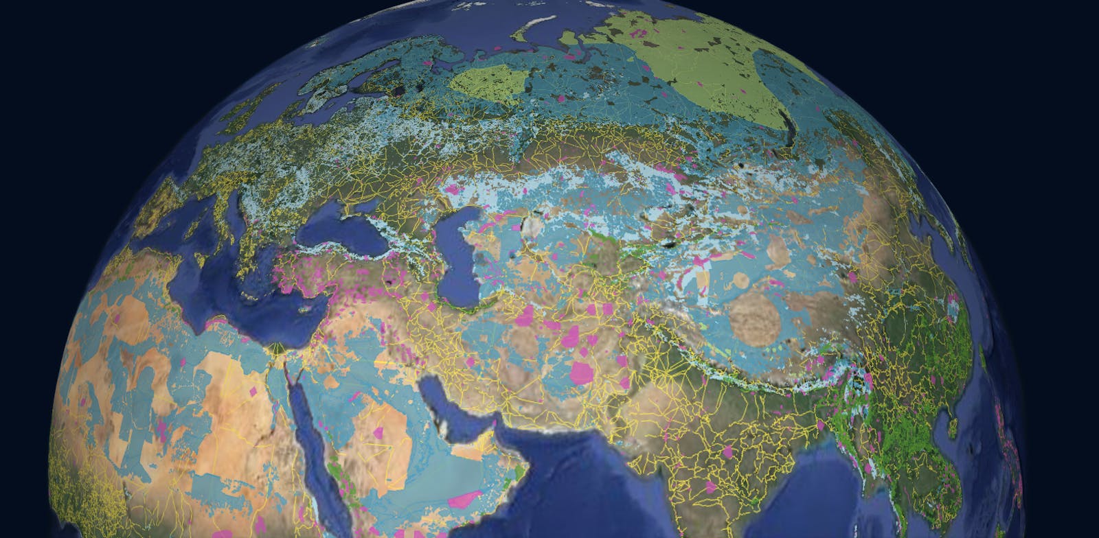
Launch the Global Safety Net Interactive Map to explore any location and help identify areas that need to be protected, connected, and restored.
The GSN Map is ideal for
- Land use managers/planners
- Educators
- Conservationists
- Elected officials/policy makers
- Media/journalists
- Everyday climate champions
-
The Global Safety Net offers the world a global stocktake of collective progress towards a robust, connected, and equitable distribution of conservation areas around the world.

Sophia Kianni
Climate Activist and UN Advisor
-
The Global Safety Net is one of the very few technological tools to support science-based decision making on conservation. It shows that a large portion of lands crucial for biodiversity and ecosystem services are safeguarded by Indigenous Peoples.

Oscar Soria
Former Campaign Director, Avaaz
-
The Global Safety Net allows us to identify globally significant ‘Rare Species sites’. Using this data we can create and expand protected areas for rare and endangered species which is critical for halting the extinction crisis.
Carly Vynne
Quick Response Fund for Nature
-
It is the location, quality and effectiveness of these protected and conserved areas that will determine whether they fulfil their role in contributing to halting biodiversity loss.

Professor Neil Burgess
Head of Science at WCMC
-
A roadmap and a literal map for saving Earth and its species from global warming.

CBS Inside Edition
How the Global Safety Net Could Save the Planet From Climate Change
-
Researchers have identified key areas of the Earth that need to be protected in order to safeguard the majority of the endangered species on our planet.

Newsweek
Scientists Call for Action To Prevent 'Sixth Great Extinction of Life'
%20tropical%20bird%20in%20Opisthocomiformes%2C%20found%20in%20swamps%2C%20riparian%20forests%2C%20and%20mangroves%20of%20the%20Amazon%20and%20the%20Orinoco%20basins%20in%20South%20America%20AdobeStock_543054723.jpg?auto=compress%2Cformat&w=1600)
%20(1).png?auto=compress%2Cformat&w=110)